Article 5:
Ameren has been using drones to spare inspection workers the risk of climbing 200-foot towers. Duke Energy uses drones for similar tasks, plus they fly them into confined spaces, such as boilers or cooling towers. Florida Power and Light had nearly 50 drone teams out surveying storm damage after Hurricane Irma.
There are plenty of uses for drones, and utilities are just getting started applying these new tools. Unmanned aviation can make dangerous jobs safer, cover more territory than crews alone and save time on tasks like inspections or storm-damage assessments. But, a drone can do even more when it’s equipped with LIDAR technology and the utility applies analytics to the data that’s been collected.
Here are some examples of what’s been done and what’s ahead
Let there be LIDAR
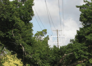
LIDAR stands for Light Detection and Ranging, and it’s a remote sensing methodology. A LIDAR device is largely made up of a laser, a GPS receiver and a scanner. Together, these measure distances of things in relationship to the earth and generate precise, three-dimensional images. Utilities can use the technology to measure infrastructure and see things like where wires sag, what clearance exists between wires and trees or which pieces of equipment are starting to show signs of excessive wear.
Drones equipped with LIDAR end the eyeball approach to line inspection, where workers walk beneath the wires, looking upward to see if there’s something wrong with the line’s right of way or guessing if tree limbs are too close. The drones also eliminate the danger of flying helicopters close to lines, plus unmanned aircraft don’t create enough static electricity from their rotor systems to affect the power distribution network.
Armed with LIDAR, drones precisely measure the distance between trees and wires. “When the data is downloaded and analyzed, you can see exactly where the tree tips are in relation to the power lines, which generates a specific cut,” says Christopher Hewlett, program leader for Deloitte’s global drone solutions consulting group. He’s been working with utilities to dovetail this data with regulations from the North American Electric Reliability Corporation (NERC) and the Federal Energy Regulatory Commission (FERC).
 “Instead of somebody saying, ‘I think that one needs to be cut,’ you definitively know the limb is violating a national regulation and the tree tip needs to be trimmed,” Hewlett notes. In addition, analytics allows utilities to apply what-if analysis to accommodate the line sag that results from high loading and the sway that comes with strong winds.
“What would happen with a higher than normal load on the wire and a 30-knot cross wind,” Hewlett asks. “Would the wire swing over and touch a tree it wasn’t touching when the drone flew by? If it does, you’re going to have a grounding situation and potentially spark a fire.”
Once utilities have indications of which trees need trimming, that data still needs to be manually input into a workforce management system. Ahead, Hewlett sees utilities looking for ways to integrate data from drones with analytics and workforce management software so that information uncovered in the unmanned flight automatically generates a work order.
The good twin
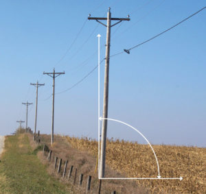 Another application for drones is collecting the data to create digital twins of assets in the field by taking high-resolution photos from multiple angles. Power poles, for instance, endure earthquakes and ground vibration as well as storm-related stresses that could leave them leaning and vulnerable. By creating a digital twin, utilities can evaluate if poles installed by a third party have been installed correctly. “If you have a contractor that didn’t install the pole correctly, you have a picture that gives you some recourse. That’s use number one,” Hewlett says.
Use number two is quick identification of leaning poles during routine inspections. Leaning is easy to spot because analytics will show when the tilt of the pole deviates from what is acceptable.
For the birds
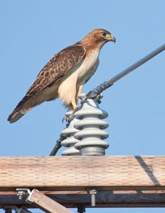 In a previous role, Hewlett recently helped a California power company comply with federal regulations on avian covers, the insulators that top ungrounded transition sections of utility power lines to inhibit a bird’s feathers from making contact with the live portion of the line. “Birds can sit on a wire and the electricity just goes through them,” Hewlett says. “One of the problems this utility was having is that birds would sit a little too close to those intersections, flap their wings and inadvertently touch the transistor and the couplers. The bird would instantly catch on fire, fall to the ground and start a brush fire.”
Hewlett and his former team designed an algorithm that recognizes avian covers and can detect cracks or deterioration. Since utility workers weren’t sure where the covers were on the lines, the algorithm helped the power company map the covers accurately and stay in compliance with regulations requiring a percentage of avian covers per line mile.
It also pinpointed covers that needed to be replaced. “We were able to determine at a 99.99999 percent accuracy that avian covers were present or not and, if present, whether they had any damage,” Hewlett says. “Utilities can spot-check all kinds of infrastructure requirements by building specific, targeted algorithms.”
In the distance
Right now, most utilities are operating drones under a limitation: Federal Aviation Administration (FAA) regulations require operators to be in visual sight of the unmanned aircraft while flying it. This past September, Xcel Energy became the first utility in the U.S. to fly a drone beyond visual line of sight during ongoing inspections of transmission lines.
The FAA granted Xcel special permission to conduct the beyond-visual-line-of-sight flights earlier this year, so now the company can operate a drone without observers or a chase aircraft. The authority to fly unmanned aircraft remotely greatly enhances this technology’s efficiency and cost-effectiveness.
“As more information becomes available to the FAA, I think utilities will see increasing opportunities for drones,” “Hewlett says. This, he adds, will be a big plus for utilities managing distribution corridors in large, geographically dispersed areas.
